


KLLQ - Monticello Muni/Ellis Fld
Located in Monticello, United States
ICAO - LLQ, IATA -
Data provided by AirmateGeneral information
Coordinates: N33°38'19" W91°45'4"
Elevation is 267 feet MSL.
Magnetic variation is 01° East View others Airports in Arkansas
Operational data
Special qualification required
Current time UTC:
Current local time:
Weather
METAR: KLLQ 250953Z AUTO 08004KT 10SM BKN085 17/12 A3010 RMK AO2 SLP191 T01670117
TAF: KLLQ 250536Z 2506/2606 VRB03KT P6SM BKN050 OVC100 FM251200 08002KT P6SM OVC050 FM251800 10007KT P6SM OVC035 FM260000 11003KT P6SM OVC100
Communications frequencies: [VIEW]
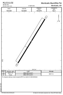
Runways:
| RWY identifier | QFU | Length (ft) | Width (ft) | Surface | LDA (ft) |
| 03 | 32° | 5020 | 75 | ASPH | |
| 21 | 212° | 5020 | 75 | ASPH |
Airport contact information
Address: Monticello United States