


KLKU - Louisa County/Freeman Fld
Located in Louisa, United States
ICAO - LKU, IATA - LOW
Data provided by AirmateGeneral information
Coordinates: N38°0'35" W77°58'12"
Elevation is 493 feet MSL.
Magnetic variation is -10° East View others Airports in Virginia
Operational data
Special qualification required
Current time UTC:
Current local time:
Weather
METAR: KLKU 181515Z AUTO 22007KT 10SM SCT050 24/13 A3001 RMK AO2 T02410128
Communications frequencies: [VIEW]
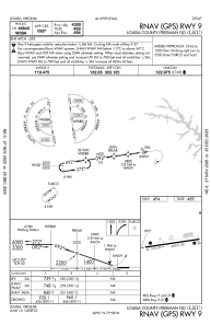
Runways:
| RWY identifier | QFU | Length (ft) | Width (ft) | Surface | LDA (ft) |
| 09 | 82° | 4300 | 100 | ASPH | |
| 27 | 262° | 4300 | 100 | ASPH |
Airport contact information
Address: Louisa United States
Other aviation service providers
Flight schools

Central Virginia Flight Services
Central Virginia Flight Services
cvflightservices@aol.com+1(540)967-1695