


KJXN - Jackson County/Reynolds Fld
Located in Jackson, United States
ICAO - JXN, IATA - JXN
Data provided by AirmateGeneral information
Coordinates: N42°15'38" W84°27'44"
Elevation is 1000 feet MSL.
Magnetic variation is -07° East View others Airports in Michigan
Operational data
Special qualification required
Current time UTC:
Current local time:
Weather
METAR: KJXN 182356Z 00000KT 10SM BKN055 BKN090 17/06 A2996 RMK AO2 SLP145 T01720056 10183 20161 58009
TAF: KJXN 182340Z 1900/1924 00000KT P6SM SKC FM190500 36008KT P6SM -RA OVC040 FM190700 33009KT 2SM -RA BR OVC008 FM191200 30012G20KT P6SM OVC015 FM191400 29014G24KT P6SM BKN040 FM191600 30016G26KT P6SM FEW040
Communications frequencies: [VIEW]
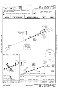
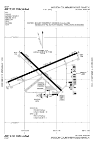
Runways:
| RWY identifier | QFU | Length (ft) | Width (ft) | Surface | LDA (ft) |
| 14 | 133° | 4000 | 100 | ASPH | |
| 32 | 313° | 4000 | 100 | ASPH | |
| 07 | 67° | 5351 | 100 | ASPH | |
| 25 | 247° | 5351 | 100 | ASPH |
Airport contact information
Address: Jackson United States