


KIAB - Mc Connell Afb
Located in Wichita, United States
ICAO - IAB, IATA - IAB
Data provided by AirmateGeneral information
Coordinates: N37°37'23" W97°16'3"
Elevation is 1371 feet MSL.
Magnetic variation is 04° East View others Airports in Kansas
Operational data
Special qualification required
Current time UTC:
Current local time:
Weather
METAR: KIAB 200855Z AUTO 04015KT 10SM OVC085 11/M02 A3030 RMK AO2 SLP262 T01091018 50007 $
TAF: TAF KIAB 200200Z 2002/2108 06009KT 9999 OVC100 QNH3021INS BECMG 2014/2015 05012G18KT 9999 BKN050 OVC070 650603 QNH3031INS BECMG 2020/2021 04009KT 9999 OVC070 650703 QNH3028INS BECMG 2102/2103 35006KT 9999 BKN050 620504 QNH3029INS TX14/2021Z TN07/2012Z
Communications frequencies: [VIEW]
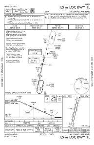
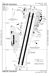
Runways:
| RWY identifier | QFU | Length (ft) | Width (ft) | Surface | LDA (ft) |
| 01R | 12° | 12007 | 150 | ASPH | |
| 19L | 192° | 12007 | 150 | ASPH | |
| 01L | 12° | 12000 | 150 | OTHER | |
| 19R | 192° | 12000 | 150 | OTHER |
Airport contact information
Address: Wichita United States