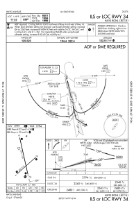
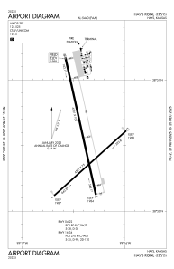


KHYS - Hays Rgnl
Located in Hays, United States
ICAO - HYS, IATA - HYS
Data provided by AirmateGeneral information
Coordinates: N38°50'32" W99°16'23"
Elevation is 1999 feet MSL.
Magnetic variation is 08° East View others Airports in Kansas
Operational data
Special qualification required
Current time UTC:
Current local time:
Weather
METAR: KHYS 250456Z AUTO 13009KT 10SM OVC040 16/04 A3002 RMK AO2 SLP158 T01610039
TAF: KHYS 242345Z 2500/2524 14013KT P6SM OVC060 FM250700 12012KT P6SM BKN025 FM251000 11012KT 5SM BR VCTS OVC009CB FM251400 09012KT 1SM -DZ OVC003
Communications frequencies: [VIEW]
Runways:
| RWY identifier | QFU | Length (ft) | Width (ft) | Surface | LDA (ft) |
| 04 | 48° | 4501 | 75 | CONC | 4500 |
| 22 | 228° | 4501 | 75 | CONC | 4500 |
| 16 | 167° | 6501 | 100 | CONC | 6501 |
| 34 | 347° | 6501 | 100 | CONC | 6501 |
Airport contact information
Address: Hays United States
