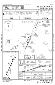
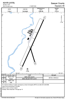


KHYR - Sawyer County
Located in Hayward, United States
ICAO - HYR, IATA - HYR
Data provided by AirmateGeneral information
Coordinates: N46°1'31" W91°26'39"
Elevation is 1216 feet MSL.
Magnetic variation is 00° East View others Airports in Wisconsin
Operational data
Special qualification required
Current time UTC:
Current local time:
Weather
METAR: KHYR 251853Z AUTO 14011G20KT 10SM CLR 16/M05 A3017 RMK AO2 SLP226 T01611050
TAF: KHYR 251729Z 2518/2618 19013KT P6SM SKC FM260900 15011G21KT P6SM SCT100 WS020/17040KT FM261600 14015G27KT 6SM -SHRA BR BKN100
Communications frequencies: [VIEW]
Runways:
| RWY identifier | QFU | Length (ft) | Width (ft) | Surface | LDA (ft) |
| 03 | 25° | 5002 | 100 | ASPH | |
| 21 | 205° | 5002 | 100 | ASPH | |
| 16 | 163° | 1088 | 120 | GRASS | |
| 34 | 343° | 1088 | 120 | GRASS |
Airport contact information
Address: Hayward United States
