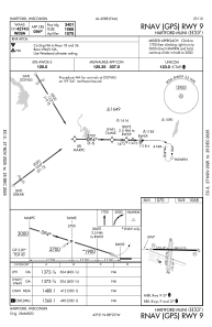


KHXF - Hartford Muni
Located in Hartford, United States
ICAO - HXF, IATA -
Data provided by AirmateGeneral information
Coordinates: N43°21'0" W88°23'25"
Elevation is 1070 feet MSL.
Magnetic variation is -03° East View others Airports in Wisconsin
Operational data
Special qualification required
Current time UTC:
Current local time:
Weather at : KETB - West Bend Muni ( 23 km )
METAR: KETB 191555Z AUTO 27017G28KT 10SM CLR 06/M06 A3004 RMK AO2
Communications frequencies: [VIEW]
Runways:
| RWY identifier | QFU | Length (ft) | Width (ft) | Surface | LDA (ft) |
| 18 | 185° | 2231 | 196 | GRASS | |
| 36 | 5° | 2231 | 196 | GRASS | |
| 09 | 91° | 3401 | 75 | ASPH | |
| 27 | 271° | 3401 | 75 | ASPH |
Airport contact information
Address: Hartford United States
