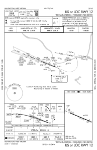
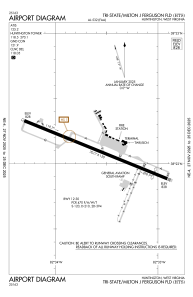


KHTS - Tri-State/Milton J Ferguson Fld
Located in Huntington, United States
ICAO - HTS, IATA - HTS
Data provided by AirmateGeneral information
Coordinates: N38°22'7" W82°33'37"
Elevation is 828 feet MSL.
Magnetic variation is -06° East View others Airports in West Virginia
Operational data
Special qualification required
Current time UTC:
Current local time:
Weather
METAR: KHTS 250651Z 02007KT 10SM FEW021 06/02 A3023 RMK AO2 SLP233 T00610017
Communications frequencies: [VIEW]
Runways:
| RWY identifier | QFU | Length (ft) | Width (ft) | Surface | LDA (ft) |
| 12 | 112° | 7017 | 150 | ASPH | 6516 |
| 30 | 292° | 7017 | 150 | ASPH | 6516 |
Airport contact information
Address: Huntington United States