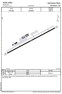


KHRI - Hermiston Muni
Located in Hermiston, United States
ICAO - HRI, IATA -
Data provided by AirmateGeneral information
Coordinates: N45°49'42" W119°15'33"
Elevation is 644 feet MSL.
Magnetic variation is 14° East View others Airports in Oregon
Operational data
Special qualification required
Current time UTC:
Current local time:
Weather
METAR: KHRI 231453Z AUTO 00000KT 10SM CLR 06/M01 A3003 RMK AO2 SLP170 T00561011 53001 $
Communications frequencies: [VIEW]
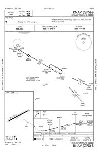
Runways:
| RWY identifier | QFU | Length (ft) | Width (ft) | Surface | LDA (ft) |
| 05 | 62° | 4501 | 75 | ASPH | |
| 23 | 242° | 4501 | 75 | ASPH |
Airport contact information
Address: Hermiston United States