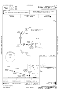
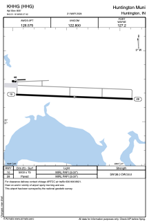


KHHG - Huntington Muni
Located in Huntington, United States
ICAO - HHG, IATA -
Data provided by AirmateGeneral information
Coordinates: N40°51'11" W85°27'25"
Elevation is 805 feet MSL.
Magnetic variation is -06° East View others Airports in Indiana
Operational data
Special qualification required
Current time UTC:
Current local time:
Weather
METAR: KHHG 250755Z AUTO 00000KT 10SM CLR 02/02 A3029 RMK AO2 T00150015
Communications frequencies: [VIEW]
Runways:
| RWY identifier | QFU | Length (ft) | Width (ft) | Surface | LDA (ft) |
| 10 | 92° | 5003 | 75 | ASPH | |
| 28 | 272° | 5003 | 75 | ASPH |
Airport contact information
Address: Huntington United States
