


KHGR - Hagerstown Rgnl/Richard A Henson Fld
Located in Hagerstown, United States
ICAO - HGR, IATA - HGR
Data provided by AirmateGeneral information
Coordinates: N39°42'31" W77°43'35"
Elevation is 703 feet MSL.
Magnetic variation is -11° East View others Airports in Maryland
Operational data
Special qualification required
Current time UTC:
Current local time:
Weather
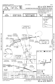
METAR: KHGR 191353Z 14007KT 10SM OVC011 12/09 A3006 RMK AO2 SLP188 T01170089 $
Communications frequencies: [VIEW]
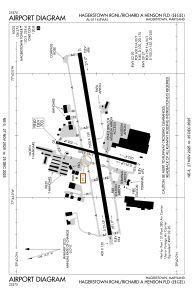
Runways:
| RWY identifier | QFU | Length (ft) | Width (ft) | Surface | LDA (ft) |
| 02 | 15° | 3165 | 100 | ASPH | 3165 |
| 20 | 195° | 3165 | 100 | ASPH | 3165 |
| 09 | 81° | 7000 | 150 | ASPH | 7000 |
| 27 | 261° | 7000 | 150 | ASPH | 7000 |
Airport contact information
Address: Hagerstown United States

