


KHFD - Hartford-Brainard
Located in Hartford, United States
ICAO - HFD, IATA -
Data provided by AirmateGeneral information
Coordinates: N41°44'12" W72°38'58"
Elevation is 18 feet MSL.
Magnetic variation is -15° East View others Airports in Connecticut
Operational data
Special qualification required
Current time UTC:
Current local time:
Communications frequencies: [VIEW]
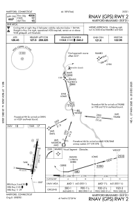
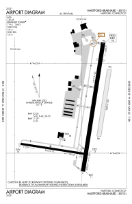
Runways:
| RWY identifier | QFU | Length (ft) | Width (ft) | Surface | LDA (ft) |
| 02 | 9° | 4417 | 150 | ASPH | |
| 20 | 189° | 4417 | 150 | ASPH | |
| 11 | 99° | 2314 | 71 | ASPH | |
| 29 | 279° | 2314 | 71 | ASPH | |
| NE | 0° | 2309 | 150 | GRASS | |
| SW | 0° | 2309 | 150 | GRASS |
Airport contact information
Address: Hartford United States
Other aviation service providers
Flight schools

Connecticut Flight Club, Inc.
Connecticut Flight Club, Inc.
connecticuitflightclub@gmail.com+1(860)888-3243
Atp Flight School (800-All-Atps)
Atp Flight School (800-All-Atps)
info@atpflightschool.com+1(800)255-2877