
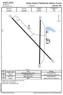


KHEZ - Hardy-Anders Fld/Natchez-Adams County
Located in Natchez, United States
ICAO - HEZ, IATA -
Data provided by AirmateGeneral information
Coordinates: N31°36'49" W91°17'50"
Elevation is 272 feet MSL.
Magnetic variation is 00° East View others Airports in Mississippi
Operational data
Special qualification required
Current time UTC:
Current local time:
Weather
METAR: KHEZ 191856Z AUTO 00000KT 10SM FEW040 SCT049 BKN055 28/19 A3004 RMK AO2 SLP171 T02780189
TAF: KHEZ 191727Z 1918/2018 26005KT P6SM BKN025 FM191900 27007KT P6SM SCT025 OVC040 FM200400 03003KT P6SM SCT007 OVC025 FM200800 00000KT 4SM BR BKN006 OVC012 FM201300 02008KT 4SM BR OVC003 FM201400 01008KT 4SM BR OVC007
Communications frequencies: [VIEW]
Runways:
| RWY identifier | QFU | Length (ft) | Width (ft) | Surface | LDA (ft) |
| 18 | 181° | 5000 | 150 | ASPH | |
| 36 | 1° | 5000 | 150 | ASPH | |
| 14 | 136° | 6500 | 150 | ASPH | |
| 32 | 316° | 6500 | 150 | ASPH |
Airport contact information
Address: Natchez United States