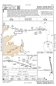
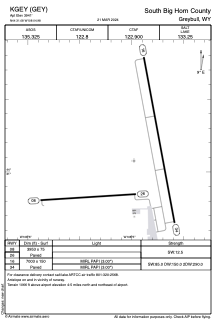


KGEY - South Big Horn County
Located in Greybull, United States
ICAO - GEY, IATA - GEY
Data provided by AirmateGeneral information
Coordinates: N44°31'5" W108°4'59"
Elevation is 3941 feet MSL.
Magnetic variation is 10° East View others Airports in Wyoming
Operational data
Special qualification required
Current time UTC:
Current local time:
Weather
METAR: KGEY 201353Z AUTO 31006KT 10SM OVC065 00/M09 A3033 RMK AO2 SLP299 T00001094
Communications frequencies: [VIEW]
Runways:
| RWY identifier | QFU | Length (ft) | Width (ft) | Surface | LDA (ft) |
| 16 | 169° | 7003 | 150 | ASPH | |
| 34 | 349° | 7003 | 150 | ASPH | |
| 08 | 86° | 3953 | 75 | ASPH | |
| 26 | 266° | 3953 | 75 | ASPH |
Airport contact information
Address: Greybull United States