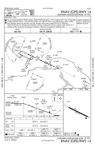


KFVE - Northern Aroostook Rgnl
Located in Frenchville, United States
ICAO - FVE, IATA - WFK
Data provided by AirmateGeneral information
Coordinates: N47°17'8" W68°18'46"
Elevation is 987 feet MSL.
Magnetic variation is -18° East View others Airports in Maine
Operational data
Special qualification required
Current time UTC:
Current local time:
Weather
METAR: KFVE 180253Z AUTO 36008KT 10SM CLR 01/M05 A3020 RMK AO2 SLP235 T00061050 51007
TAF: KFVE 172320Z 1800/1824 35008KT P6SM OVC050 FM180200 36004KT P6SM SKC FM181400 03008KT P6SM SCT050
Communications frequencies: [VIEW]
Runways:
| RWY identifier | QFU | Length (ft) | Width (ft) | Surface | LDA (ft) |
| 14 | 116° | 4600 | 75 | ASPH | |
| 32 | 296° | 4600 | 75 | ASPH |
Airport contact information
Address: Frenchville United States
