


KFRH - French Lick Muni
Located in French Lick, United States
ICAO - FRH, IATA - FRH
Data provided by AirmateGeneral information
Coordinates: N38°30'22" W86°38'13"
Elevation is 792 feet MSL.
Magnetic variation is -04° East View others Airports in Indiana
Operational data
Special qualification required
Current time UTC:
Current local time:
Weather
METAR: KFRH 200855Z AUTO 00000KT 10SM CLR 08/00 A3019 RMK AO1
Communications frequencies: [VIEW]
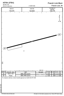
Runways:
| RWY identifier | QFU | Length (ft) | Width (ft) | Surface | LDA (ft) |
| 08 | 76° | 5500 | 100 | ASPH | 5309 |
| 26 | 256° | 5500 | 100 | ASPH | 5298 |
Airport contact information
Address: French Lick United States