


KFOE - Topeka Rgnl
Located in Topeka, United States
ICAO - FOE, IATA - FOE
Data provided by AirmateGeneral information
Coordinates: N38°57'3" W95°39'49"
Elevation is 1077 feet MSL.
Magnetic variation is 05° East View others Airports in Kansas
Operational data
Special qualification required
Current time UTC:
Current local time:
Weather
METAR: KFOE 242153Z 20006KT 8SM FU CLR 22/03 A3013 RMK AO2 SLP199 T02220033 $
TAF: KFOE 241736Z 2418/2518 09005KT P6SM SCT140 FM251400 12011KT P6SM VCSH BKN013
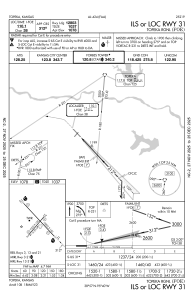
Communications frequencies: [VIEW]
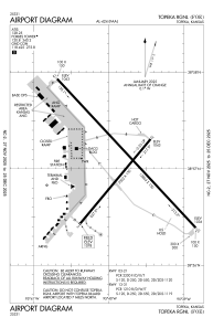
Runways:
| RWY identifier | QFU | Length (ft) | Width (ft) | Surface | LDA (ft) |
| 03 | 40° | 7002 | 150 | ASPH | 7001 |
| 21 | 220° | 7002 | 150 | ASPH | 7001 |
| 13 | 137° | 12803 | 150 | CONC | 12803 |
| 31 | 317° | 12803 | 150 | CONC | 12803 |
Airport contact information
Address: Topeka United States