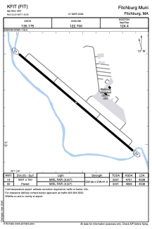


KFIT - Fitchburg Muni
Located in Fitchburg, United States
ICAO - FIT, IATA -
Data provided by AirmateGeneral information
Coordinates: N42°33'14" W71°45'33"
Elevation is 344 feet MSL.
Magnetic variation is -15° East View others Airports in Massachusetts
Operational data
Special qualification required
Current time UTC:
Current local time:
Weather
METAR: KFIT 191852Z AUTO 18010G17KT 10SM CLR 15/M01 A3008 RMK AO2 SLP189 T01501006
Communications frequencies: [VIEW]
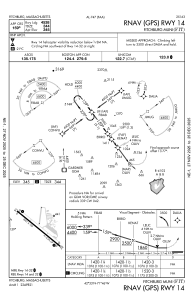
Runways:
| RWY identifier | QFU | Length (ft) | Width (ft) | Surface | LDA (ft) |
| 14 | 130° | 5001 | 100 | ASPH | 4538 |
| 32 | 310° | 5001 | 100 | ASPH | 4538 |
Airport contact information
Address: Fitchburg United States

