


KFAT - Fresno Yosemite Intl
Located in Fresno, United States
ICAO - FAT, IATA - FAT
Data provided by AirmateGeneral information
Coordinates: N36°46'36" W119°43'8"
Elevation is 335 feet MSL.
Magnetic variation is 13° East View others Airports in California
Operational data
Special qualification required
Current time UTC:
Current local time:
Weather
METAR: KFAT 250153Z 36005KT 10SM SCT080 BKN130 BKN200 18/09 A3000 RMK AO2 SLP156 T01830094
TAF: KFAT 242320Z 2500/2524 31008KT P6SM BKN040
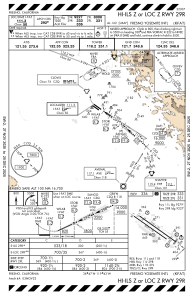
Communications frequencies: [VIEW]
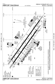
Runways:
| RWY identifier | QFU | Length (ft) | Width (ft) | Surface | LDA (ft) |
| 11R | 125° | 8008 | 150 | ASPH | 8008 |
| 29L | 305° | 8008 | 150 | ASPH | 8008 |
| 11L | 125° | 9539 | 150 | ASPH | 9279 |
| 29R | 305° | 9539 | 150 | ASPH | 9227 |
Airport contact information
Address: Fresno United States

