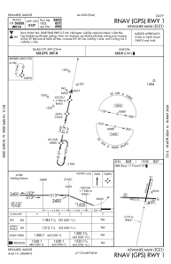
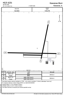


KEZI - Kewanee Muni
Located in Kewanee, United States
ICAO - EZI, IATA -
Data provided by AirmateGeneral information
Coordinates: N41°12'19" W89°57'50"
Elevation is 858 feet MSL.
Magnetic variation is -02° East View others Airports in Illinois
Operational data
Special qualification required
Current time UTC:
Current local time:
Weather at : KGBG - Galesburg Muni ( 49 km )
METAR: KGBG 230835Z AUTO 20010G15KT 10SM SCT075 BKN100 13/04 A2982 RMK AO2 T01290037
Communications frequencies: [VIEW]
Runways:
| RWY identifier | QFU | Length (ft) | Width (ft) | Surface | LDA (ft) |
| 01 | 11° | 3200 | 60 | ASPH | |
| 19 | 191° | 3200 | 60 | ASPH | |
| 09 | 91° | 4500 | 75 | ASPH | |
| 27 | 271° | 4500 | 75 | ASPH |
Airport contact information
Address: Kewanee United States
