


KEYE - Eagle Creek Airpark
Located in Indianapolis, United States
ICAO - EYE, IATA -
Data provided by AirmateGeneral information
Coordinates: N39°49'51" W86°17'40"
Elevation is 822 feet MSL.
Magnetic variation is -05° East View others Airports in Indiana
Operational data
Special qualification required
Current time UTC:
Current local time:
Weather
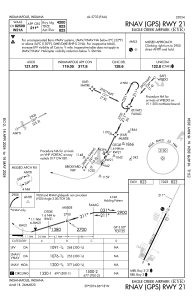
METAR: KEYE 190533Z AUTO 27008G15KT 6SM -RA BR SCT007 OVC014 16/14 A2986 RMK AO2 RAE14B32 P0001 T01560139
Communications frequencies: [VIEW]
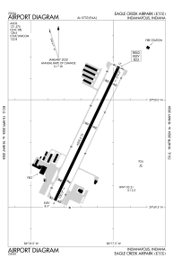
Runways:
| RWY identifier | QFU | Length (ft) | Width (ft) | Surface | LDA (ft) |
| 03 | 26° | 4200 | 75 | ASPH | |
| 21 | 206° | 4200 | 75 | ASPH |
Airport contact information
Address: Indianapolis United States
