


KEHR - Henderson City-County
Located in Henderson, United States
ICAO - EHR, IATA -
Data provided by AirmateGeneral information
Coordinates: N37°48'28" W87°41'8"
Elevation is 386 feet MSL.
Magnetic variation is -01° East View others Airports in Kentucky
Operational data
Special qualification required
Current time UTC:
Current local time:
Weather
METAR: KEHR 251456Z AUTO 08006KT 10SM CLR 13/06 A3029 RMK AO2 SLP256 T01280056 50005
Communications frequencies: [VIEW]
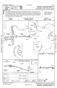
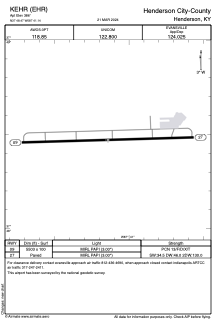
Runways:
| RWY identifier | QFU | Length (ft) | Width (ft) | Surface | LDA (ft) |
| 09 | 88° | 5503 | 100 | ASPH | |
| 27 | 268° | 5503 | 100 | ASPH |
Airport contact information
Address: Henderson United States
