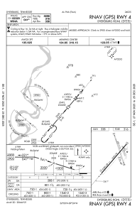


KDYR - Dyersburg Rgnl
Located in Dyersburg, United States
ICAO - DYR, IATA -
Data provided by AirmateGeneral information
Coordinates: N35°59'53" W89°24'24"
Elevation is 337 feet MSL.
Magnetic variation is -01° East View others Airports in Tennessee
Operational data
Special qualification required
Current time UTC:
Current local time:
Weather
METAR: KDYR 181156Z AUTO 13004KT 10SM BKN017 20/ A3003 RMK AO2 SLP171 6//// 7//// T0200 10206 20189 51008
Communications frequencies: [VIEW]
Runways:
| RWY identifier | QFU | Length (ft) | Width (ft) | Surface | LDA (ft) |
| 04 | 40° | 5698 | 98 | ASPH | |
| 22 | 221° | 5698 | 98 | ASPH | |
| 16 | 162° | 4001 | 74 | ASPH | |
| 34 | 342° | 4001 | 74 | ASPH |
Airport contact information
Address: Dyersburg United States