


KDVT - Phoenix Deer Valley
Located in Phoenix, United States
ICAO - DVT, IATA - DVT
Data provided by AirmateGeneral information
Coordinates: N33°41'18" W112°4'57"
Elevation is 1478 feet MSL.
Magnetic variation is 12° East View others Airports in Arizona
Operational data
Special qualification required
Current time UTC:
Current local time:
Weather
METAR: KDVT 240753Z AUTO 26004KT 10SM CLR 22/M04 A2992 RMK AO2 SLP108 T02221044
TAF: KDVT 240532Z 2406/2506 25006KT P6SM SKC FM240700 VRB04KT P6SM SKC FM241600 17008KT P6SM SCT250 FM242200 20010G17KT P6SM SKC FM250300 23009KT P6SM SKC
Communications frequencies: [VIEW]
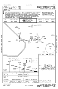
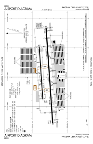
Runways:
| RWY identifier | QFU | Length (ft) | Width (ft) | Surface | LDA (ft) |
| 07R | 86° | 8196 | 100 | ASPH | 7299 |
| 25L | 266° | 8196 | 100 | ASPH | 7281 |
| 07L | 86° | 4500 | 75 | ASPH | |
| 25R | 266° | 4500 | 75 | ASPH |
Airport contact information
Address: Phoenix United States
Other aviation service providers
Flight schools

AeroGuard Flight Training Center
AeroGuard Flight Training Center
marketing@flyaeroguard.com+1-800-322-1526
Westwind School Of Aeronautics
Westwind School Of Aeronautics
admissions@westwindaviation.com+1(623)869-6973