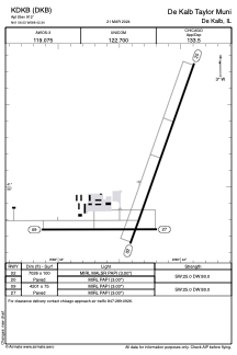


KDKB - De Kalb Taylor Muni
Located in De Kalb, United States
ICAO - DKB, IATA -
Data provided by AirmateGeneral information
Coordinates: N41°56'2" W88°42'20"
Elevation is 912 feet MSL.
Magnetic variation is -02° East View others Airports in Illinois
Operational data
Special qualification required
Current time UTC:
Current local time:
Weather
METAR: KDKB 200715Z AUTO 28012G17KT 10SM CLR 02/M07 A3017 RMK AO2 T00171066
Communications frequencies: [VIEW]
Runways:
| RWY identifier | QFU | Length (ft) | Width (ft) | Surface | LDA (ft) |
| 02 | 19° | 7026 | 100 | ASPH | |
| 20 | 199° | 7026 | 100 | ASPH | |
| 09 | 90° | 4201 | 75 | ASPH | |
| 27 | 270° | 4201 | 75 | ASPH |
Airport contact information
Address: De Kalb United States
