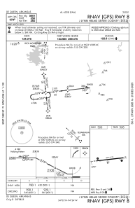
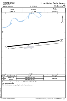


KDEQ - J Lynn Helms Sevier County
Located in De Queen, United States
ICAO - DEQ, IATA -
Data provided by AirmateGeneral information
Coordinates: N34°2'49" W94°23'58"
Elevation is 354 feet MSL.
Magnetic variation is 04° East View others Airports in Arkansas
Operational data
Special qualification required
Current time UTC:
Current local time:
Weather
METAR: KDEQ 230853Z AUTO 00000KT 10SM CLR 08/07 A3004 RMK AO2 SLP170 T00780067 56012
Communications frequencies: [VIEW]
Runways:
| RWY identifier | QFU | Length (ft) | Width (ft) | Surface | LDA (ft) |
| 08 | 83° | 5001 | 75 | ASPH | |
| 26 | 263° | 5001 | 75 | ASPH |
Airport contact information
Address: De Queen United States