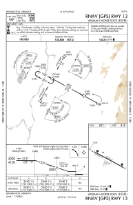
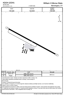


KDDH - William H Morse State
Located in Bennington, United States
ICAO - DDH, IATA -
Data provided by AirmateGeneral information
Coordinates: N42°53'29" W73°14'47"
Elevation is 826 feet MSL.
Magnetic variation is -14° East View others Airports in Vermont
Operational data
Special qualification required
Current time UTC:
Current local time:
Weather
METAR: KDDH 250354Z AUTO 00000KT 10SM CLR M01/M03 A3018 RMK AO2 SLP225 T10061033
Communications frequencies: [VIEW]
Runways:
| RWY identifier | QFU | Length (ft) | Width (ft) | Surface | LDA (ft) |
| 13 | 118° | 3704 | 75 | ASPH | |
| 31 | 298° | 3704 | 75 | ASPH |
Airport contact information
Address: Bennington United States