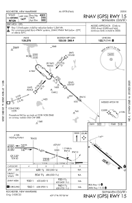


KDAW - Skyhaven
Located in Rochester, United States
ICAO - DAW, IATA -
Data provided by AirmateGeneral information
Coordinates: N43°17'3" W70°55'46"
Elevation is 322 feet MSL.
Magnetic variation is -16° East View others Airports in New Hampshire
Operational data
Special qualification required
Current time UTC:
Current local time:
Weather
METAR: KDAW 200851Z AUTO 18003KT 10SM -RA OVC047 08/05 A2993 RMK AO2 RAB20 SLP133 P0001 60001 T00830050 58016
Communications frequencies: [VIEW]
Runways:
| RWY identifier | QFU | Length (ft) | Width (ft) | Surface | LDA (ft) |
| 15 | 131° | 4201 | 75 | ASPH | |
| 33 | 311° | 4201 | 75 | ASPH |
Airport contact information
Address: Rochester United States