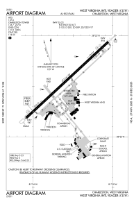


KCRW - West Virginia Intl Yeager
Located in Charleston, United States
ICAO - CRW, IATA - CRW
Data provided by AirmateGeneral information
Coordinates: N38°22'34" W81°35'34"
Elevation is 947 feet MSL.
Magnetic variation is -06° East View others Airports in West Virginia
Operational data
Special qualification required
Current time UTC:
Current local time:
Weather
METAR: KCRW 230654Z 00000KT 10SM CLR 04/M01 A3010 RMK AO2 SLP194 T00441011
TAF: KCRW 230520Z 2306/2406 00000KT P6SM SCT200 FM231300 20004KT P6SM FEW200 FM232100 22011G19KT P6SM BKN200 FM240400 23009G18KT 6SM -RA BR OVC050
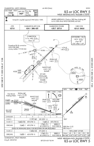
Communications frequencies: [VIEW]
Runways:
| RWY identifier | QFU | Length (ft) | Width (ft) | Surface | LDA (ft) |
| 05 | 47° | 6715 | 150 | ASPH | 6215 |
| 23 | 227° | 6715 | 150 | ASPH | 6215 |
Airport contact information
Address: Charleston United States