
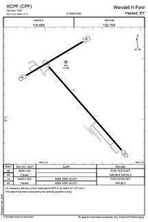


KCPF - Wendell H Ford
Located in Hazard, United States
ICAO - CPF, IATA -
Data provided by AirmateGeneral information
Coordinates: N37°23'14" W83°15'42"
Elevation is 1256 feet MSL.
Magnetic variation is -06° East View others Airports in Kentucky
Operational data
Special qualification required
Current time UTC:
Current local time:
Communications frequencies: [VIEW]
Runways:
| RWY identifier | QFU | Length (ft) | Width (ft) | Surface | LDA (ft) |
| 06 | 59° | 3246 | 60 | ASPH | |
| 14 | 139° | 5499 | 100 | ASPH | |
| 24 | 239° | 3246 | 60 | ASPH | |
| 32 | 319° | 5499 | 100 | ASPH |
Airport contact information
Address: Hazard United States
