


KCPC - Columbus County Muni
Located in Whiteville, United States
ICAO - CPC, IATA -
Data provided by AirmateGeneral information
Coordinates: N34°16'22" W78°42'54"
Elevation is 99 feet MSL.
Magnetic variation is -07° East View others Airports in North Carolina
Operational data
Special qualification required
Current time UTC:
Current local time:
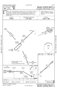
Communications frequencies: [VIEW]
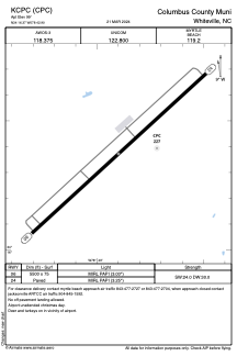
Runways:
| RWY identifier | QFU | Length (ft) | Width (ft) | Surface | LDA (ft) |
| 06 | 48° | 5500 | 75 | ASPH | |
| 24 | 228° | 5500 | 75 | ASPH |
Airport contact information
Address: Whiteville United States