
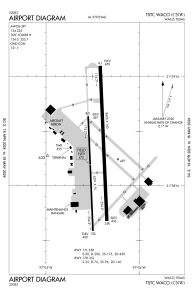


KCNW - Tstc Waco
Located in Waco, United States
ICAO - CNW, IATA - CNW
Data provided by AirmateGeneral information
Coordinates: N31°38'16" W97°4'27"
Elevation is 470 feet MSL.
Magnetic variation is 04° East View others Airports in Texas
Operational data
Special qualification required
Current time UTC:
Current local time:
Weather
METAR: KCNW 201155Z 02003KT 7SM -DZ OVC006 18/18 A3004
Communications frequencies: [VIEW]
Runways:
| RWY identifier | QFU | Length (ft) | Width (ft) | Surface | LDA (ft) |
| 17R | 178° | 6291 | 75 | CONC | |
| 35L | 358° | 6291 | 75 | CONC | |
| 17L | 178° | 8600 | 150 | ASPH | |
| 35R | 358° | 8600 | 150 | ASPH |
Airport contact information
Address: Waco United States