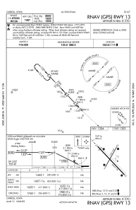


KCIN - Arthur N Neu
Located in Carroll, United States
ICAO - CIN, IATA - CIN
Data provided by AirmateGeneral information
Coordinates: N42°2'48" W94°47'19"
Elevation is 1203 feet MSL.
Magnetic variation is 02° East View others Airports in Iowa
Operational data
Special qualification required
Current time UTC:
Current local time:
Weather
METAR: KCIN 160615Z AUTO 13018G24KT 10SM BKN049 BKN055 OVC075 19/03 A2969 RMK AO2
Communications frequencies: [VIEW]
Runways:
| RWY identifier | QFU | Length (ft) | Width (ft) | Surface | LDA (ft) |
| 03 | 30° | 3301 | 60 | CONC | |
| 21 | 210° | 3301 | 60 | CONC | |
| 13 | 137° | 5506 | 100 | CONC | |
| 31 | 317° | 5506 | 100 | CONC |
Airport contact information
Address: Carroll United States
