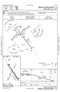


KCHT - Chillicothe Muni
Located in Chillicothe, United States
ICAO - CHT, IATA -
Data provided by AirmateGeneral information
Coordinates: N39°46'55" W93°29'46"
Elevation is 783 feet MSL.
Magnetic variation is 03° East View others Airports in Missouri
Operational data
Special qualification required
Current time UTC:
Current local time:
Weather at : KEZZ - Cameron Meml ( 67 km )
METAR: KEZZ 191415Z AUTO 00000KT 10SM CLR 08/M02 A3031 RMK AO2 T00771015
Communications frequencies: [VIEW]
Runways:
| RWY identifier | QFU | Length (ft) | Width (ft) | Surface | LDA (ft) |
| 02 | 26° | 3503 | 110 | GRASS | |
| 20 | 206° | 3503 | 110 | GRASS | |
| 14 | 143° | 3899 | 75 | CONC | |
| 32 | 323° | 3899 | 75 | CONC |
Airport contact information
Address: Chillicothe United States