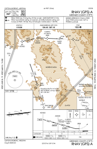


KCFT - Greenlee County
Located in Clifton/Morenci, United States
ICAO - CFT, IATA - CFT
Data provided by AirmateGeneral information
Coordinates: N32°57'25" W109°12'40"
Elevation is 3797 feet MSL.
Magnetic variation is 10° East View others Airports in Arizona
Operational data
Special qualification required
Current time UTC:
Current local time:
Weather at : KSAD - Safford Rgnl ( 41 km )
METAR: KSAD 201551Z AUTO 09009KT 10SM CLR 23/M03 A2999 RMK AO2 SLP109 T02281033
Communications frequencies: [VIEW]
Runways:
| RWY identifier | QFU | Length (ft) | Width (ft) | Surface | LDA (ft) |
| 07 | 84° | 4978 | 75 | ASPH | |
| 25 | 264° | 4978 | 75 | ASPH |
Airport contact information
Address: Clifton/Morenci United States