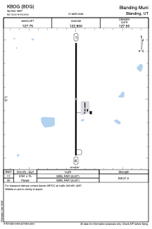


KBDG - Blanding Muni
Located in Blanding, United States
ICAO - BDG, IATA - BDG
Data provided by AirmateGeneral information
Coordinates: N37°34'60" W109°28'60"
Elevation is 5867 feet MSL.
Magnetic variation is 12° East View others Airports in Utah
Operational data
Special qualification required
Current time UTC:
Current local time:
Weather
METAR: KBDG 200035Z AUTO 25013KT 8SM OVC160 21/M09 A2995 RMK AO2 T02051093
Communications frequencies: [VIEW]
Runways:
| RWY identifier | QFU | Length (ft) | Width (ft) | Surface | LDA (ft) |
| 17 | 180° | 5781 | 75 | ASPH | |
| 35 | 0° | 5781 | 75 | ASPH |
Airport contact information
Address: Blanding United States