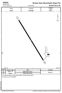


KBBW - Broken Bow Muni/Keith Glaze Fld
Located in Broken Bow, United States
ICAO - BBW, IATA - BBW
Data provided by AirmateGeneral information
Coordinates: N41°26'11" W99°38'32"
Elevation is 2546 feet MSL.
Magnetic variation is 08° East View others Airports in Nebraska
Operational data
Special qualification required
Current time UTC:
Current local time:
Weather
METAR: KBBW 252153Z AUTO 11014G22KT 10SM OVC016 16/13 A2973 RMK AO2 SLP059 T01610128
Communications frequencies: [VIEW]
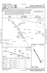
Runways:
| RWY identifier | QFU | Length (ft) | Width (ft) | Surface | LDA (ft) |
| 14 | 149° | 4203 | 75 | CONC | |
| 32 | 329° | 4203 | 75 | CONC |
Airport contact information
Address: Broken Bow United States