


KAZO - Kalamazoo/Battle Creek Intl
Located in Kalamazoo, United States
ICAO - AZO, IATA - AZO
Data provided by AirmateGeneral information
Coordinates: N42°14'4" W85°33'6"
Elevation is 873 feet MSL.
Magnetic variation is -03° East View others Airports in Michigan
Operational data
Special qualification required
Current time UTC:
Current local time:
Weather
METAR: KAZO 242053Z 34007KT 300V360 10SM OVC034 09/01 A3024 RMK AO2 SLP246 T00940006 50000
TAF: KAZO 241720Z 2418/2518 02009KT P6SM BKN025 FM241900 02007KT P6SM BKN035 FM242000 01007KT P6SM SCT060 FM250100 VRB03KT P6SM FEW250 FM251500 13004KT P6SM SKC
Communications frequencies: [VIEW]
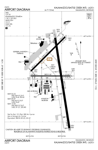
Runways:
| RWY identifier | QFU | Length (ft) | Width (ft) | Surface | LDA (ft) |
| 05 | 45° | 3438 | 100 | ASPH | 3439 |
| 23 | 225° | 3438 | 100 | ASPH | 3439 |
| 09 | 90° | 2800 | 60 | ASPH | 2800 |
| 27 | 270° | 2800 | 60 | ASPH | 2800 |
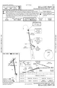
| 17 | 171° | 6502 | 150 | ASPH | 6502 |
| 35 | 351° | 6502 | 150 | ASPH | 6502 |
Airport contact information
Address: Kalamazoo United States
Other aviation service providers
Flight schools

Kal-Aero Flight Instruction
Kal-Aero Flight Instruction
kalaeroflightinstruction@gmail.com+1(269)459-8967