


KAXX - Angel Fire
Located in Angel Fire, United States
ICAO - AXX, IATA - AXX
Data provided by AirmateGeneral information
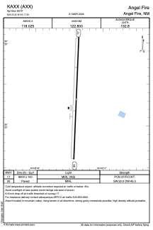
Coordinates: N36°25'19" W105°17'24"
Elevation is 8379 feet MSL.
Magnetic variation is 10° East View others Airports in New Mexico
Operational data
Special qualification required
Current time UTC:
Current local time:
Weather
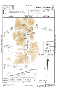
METAR: KAXX 250455Z AUTO 22011KT 10SM CLR 12/M06 A3018 RMK AO2 T01201064
Communications frequencies: [VIEW]
Runways:
| RWY identifier | QFU | Length (ft) | Width (ft) | Surface | LDA (ft) |
| 17 | 182° | 8900 | 100 | ASPH | |
| 35 | 2° | 8900 | 100 | ASPH |
Airport contact information
Address: Angel Fire United States