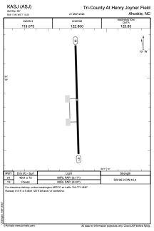


KASJ - Tri-County At Henry Joyner Field
Located in Ahoskie, United States
ICAO - ASJ, IATA -
Data provided by AirmateGeneral information
Coordinates: N36°17'51" W77°10'15"
Elevation is 66 feet MSL.
Magnetic variation is -10° East View others Airports in North Carolina
Operational data
Special qualification required
Current time UTC:
Current local time:
Weather
METAR: KASJ 191855Z AUTO 13008KT 10SM CLR 22/13 A3001 RMK AO2 T02160130
Communications frequencies: [VIEW]
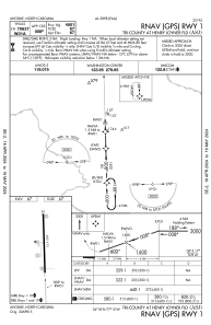
Runways:
| RWY identifier | QFU | Length (ft) | Width (ft) | Surface | LDA (ft) |
| 01 | 358° | 4501 | 75 | ASPH | |
| 19 | 178° | 4501 | 75 | ASPH |
Airport contact information
Address: Ahoskie United States