


KANB - Anniston Rgnl
Located in Anniston, United States
ICAO - ANB, IATA - ANB
Data provided by AirmateGeneral information
Coordinates: N33°35'17" W85°51'29"
Elevation is 612 feet MSL.
Magnetic variation is -04° East View others Airports in Alabama
Operational data
Special qualification required
Current time UTC:
Current local time:
Weather
METAR: KANB 180718Z AUTO 00000KT 1 3/4SM BR BKN003 16/16 A3008 RMK AO2 VIS 3/4V2 1/2 T01610156
TAF: KANB 180529Z 1806/1906 00000KT 4SM BR BKN060 FM180900 00000KT 2SM BR SCT007 BKN025 TEMPO 1810/1813 1SM BR BKN007 OVC030 FM181500 06003KT P6SM BKN025 FM181700 09003KT P6SM BKN050 PROB30 1900/1906 4SM -SHRA BR OVC050
Communications frequencies: [VIEW]
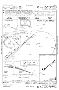
Runways:
| RWY identifier | QFU | Length (ft) | Width (ft) | Surface | LDA (ft) |
| 05 | 48° | 7000 | 150 | ASPH | |
| 23 | 228° | 7000 | 150 | ASPH |
Airport contact information
Address: Anniston United States
