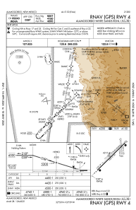
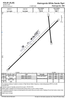


KALM - Alamogordo-White Sands Rgnl
Located in Alamogordo, United States
ICAO - ALM, IATA - ALM
Data provided by AirmateGeneral information
Coordinates: N32°50'22" W105°59'28"
Elevation is 4199 feet MSL.
Magnetic variation is 08° East View others Airports in New Mexico
Operational data
Special qualification required
Current time UTC:
Current local time:
Weather
METAR: KALM 250855Z AUTO 05004KT 10SM CLR 17/M08 A2996 RMK AO2
Communications frequencies: [VIEW]
Runways:
| RWY identifier | QFU | Length (ft) | Width (ft) | Surface | LDA (ft) |
| 04 | 46° | 9207 | 150 | ASPH | 9207 |
| 22 | 226° | 9207 | 150 | ASPH | 9207 |
| 17 | 174° | 3257 | 190 | EARTH | |
| 35 | 354° | 3257 | 190 | EARTH |
Airport contact information
Address: Alamogordo United States
