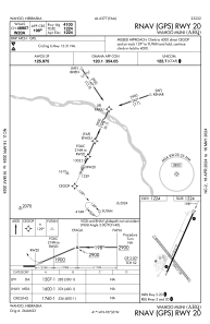


KAHQ - Wahoo Muni
Located in Wahoo, United States
ICAO - AHQ, IATA -
Data provided by AirmateGeneral information
Coordinates: N41°14'26" W96°35'40"
Elevation is 1223 feet MSL.
Magnetic variation is 06° East View others Airports in Nebraska
Operational data
Special qualification required
Current time UTC:
Current local time:
Communications frequencies: [VIEW]
Runways:
| RWY identifier | QFU | Length (ft) | Width (ft) | Surface | LDA (ft) |
| 02 | 24° | 4100 | 75 | CONC | |
| 20 | 204° | 4100 | 75 | CONC | |
| 13 | 141° | 3290 | 150 | GRASS | |
| 31 | 321° | 3290 | 150 | GRASS |
Airport contact information
Address: Wahoo United States