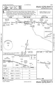


KAGZ - Wagner Muni
Located in Wagner, United States
ICAO - AGZ, IATA -
Data provided by AirmateGeneral information
Coordinates: N43°3'51" W98°17'47"
Elevation is 1477 feet MSL.
Magnetic variation is 04° East View others Airports in South Dakota
Operational data
Special qualification required
Current time UTC:
Current local time:
Communications frequencies: [VIEW]
Runways:
| RWY identifier | QFU | Length (ft) | Width (ft) | Surface | LDA (ft) |
| 09 | 94° | 3500 | 60 | ASPH | |
| 27 | 274° | 3500 | 60 | ASPH | |
| 14 | 148° | 2252 | 150 | GRASS | |
| 32 | 328° | 2252 | 150 | GRASS |
Airport contact information
Address: Wagner United States