


K51 - Medicine Lodge
Located in Medicine Lodge, United States
ICAO - K51, IATA -
Data provided by AirmateGeneral information
Coordinates: N37°15'55" W98°32'52"
Elevation is 1549 feet MSL.
Magnetic variation is 07° East View others Airports in Kansas
Operational data
Special qualification required
Current time UTC:
Current local time:
Communications frequencies: [VIEW]
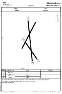
Runways:
| RWY identifier | QFU | Length (ft) | Width (ft) | Surface | LDA (ft) |
| 13 | 145° | 1690 | 80 | GRASS | |
| 31 | 325° | 1690 | 80 | GRASS | |
| 16 | 174° | 3200 | 42 | ASPH | |
| 34 | 354° | 3200 | 42 | ASPH |
Airport contact information
Address: Medicine Lodge United States