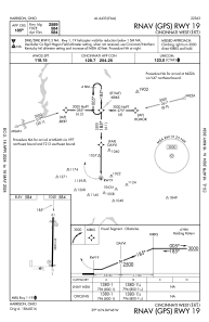


I67 - Cincinnati West
Located in Harrison, United States
ICAO - I67, IATA -
Data provided by AirmateGeneral information
Coordinates: N39°15'33" W84°46'28"
Elevation is 584 feet MSL.
Magnetic variation is -05° East View others Airports in Ohio
Operational data
Special qualification required
Current time UTC:
Current local time:
Communications frequencies: [VIEW]
Runways:
| RWY identifier | QFU | Length (ft) | Width (ft) | Surface | LDA (ft) |
| 01 | 0° | 2808 | 60 | ASPH | |
| 19 | 180° | 2808 | 60 | ASPH |
Airport contact information
Address: Harrison United States
