


HLZG - Oxy - 103A
Located in Ajdabiyah, Libyan Arab Jamahiriya
ICAO - HLZG, IATA -
Data provided by AirmateGeneral information
Coordinates: N29°0'22" E20°47'10"
Elevation is 329 feet MSL.
Magnetic variation is 4° East View others Airports in Al Wahat District
Operational data
Special qualification required
Current time UTC:
Current local time:
Weather at : - ( 0 km )
METAR: KVAF 192240Z AUTO 07011KT 1 1/2SM HZ CLR 25/22 A2997 RMK A01
Communications frequencies: [VIEW]
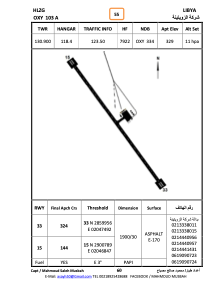
Runways:
| RWY identifier | QFU | Length (ft) | Width (ft) | Surface | LDA (ft) |
| 15 | 146° | 6209 | 101 | ASPH | |
| 33 | 326° | 6209 | 101 | ASPH |
Airport contact information
Address: Ajdabiyah Libyan Arab Jamahiriya