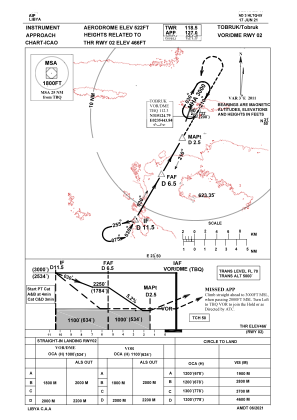
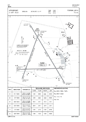


HLTQ - Tobruk
Located in Tobruk, Libyan Arab Jamahiriya
ICAO - , IATA - TOB
Data provided by AirmateGeneral information
Coordinates: N31°51'17" E23°53'45"
Elevation is 522 feet MSL.
Magnetic variation is 4° East View others Airports in Al Butnan District
Operational data
Special qualification required
Current time UTC:
Current local time:
Weather at : - ( 0 km )
METAR: KPAO 252147Z 25015G22KT 10SM BKN032 17/09 A3012
Communications frequencies: [VIEW]
Runways:
| RWY identifier | QFU | Length (ft) | Width (ft) | Surface | LDA (ft) |
| 02 | 20° | 9823 | 131 | CONC ASPH | |
| 20 | 200° | 9823 | 131 | CONC ASPH | |
| 08 | 89° | 9725 | 125 | CONC ASPH | |
| 26 | 269° | 9725 | 125 | CONC ASPH |
Airport contact information
Address: Tobruk Libyan Arab Jamahiriya