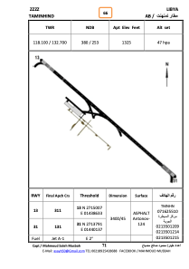


HLTM - Taminhint
Located in Sebha, Libyan Arab Jamahiriya
ICAO - , IATA -
Data provided by AirmateGeneral information
Coordinates: N27°14'20" E14°39'22"
Elevation is 1325 feet MSL.
Magnetic variation is 3° East View others Airports in Sabha District
Operational data
Special qualification required
Current time UTC:
Current local time:
Weather at : - ( 0 km )
METAR: PPIZ 252256Z AUTO 08024KT 5SM BR FEW080 BKN095 M06/M08 A2994 RMK AO2 PK WND 08030/2237 SLP141 T10561078 FZRANO
Communications frequencies: [VIEW]
Runways:
| RWY identifier | QFU | Length (ft) | Width (ft) | Surface | LDA (ft) |
| 13 | 132° | 11123 | 145 | ASPH | |
| 31 | 312° | 11123 | 145 | ASPH |
Airport contact information
Address: Sebha Libyan Arab Jamahiriya