


HLRA - Dahra Wh-32
Located in , Libyan Arab Jamahiriya
ICAO - HLRA, IATA -
Data provided by AirmateGeneral information
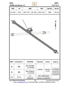
Coordinates: N29°28'16" E17°55'45"
Elevation is 1086 feet MSL.
Magnetic variation is 3° East View others Airports in Surt District
Operational data
Special qualification required
Current time UTC:
Current local time:
Weather at : - ( 0 km )
METAR: CYVM 250753Z AUTO 20010KT 9SM -SN SCT120 BKN150 M08/M09 A2984 RMK SLP107
Communications frequencies: [VIEW]
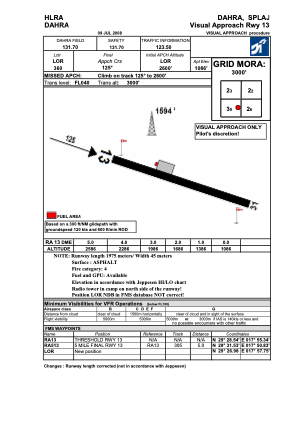
Runways:
| RWY identifier | QFU | Length (ft) | Width (ft) | Surface | LDA (ft) |
| 13 | 127° | 6860 | 109 | ASPH | |
| 31 | 307° | 6860 | 109 | ASPH | |
| 09 | 89° | 3582 | 96 | SAND | |
| 27 | 269° | 3582 | 96 | SAND |
Airport contact information
Address: Libyan Arab Jamahiriya